In 2016, Donegal (a county in the Republic of Ireland), became the centre of a pilot scheme intended to change how drones are used by emergency response teams. One of the groups that took part in this scheme was Donegal Mountain Rescue Team which is made of volunteers from around Ireland. DroneSAR, an Irish tech startup, were behind the scheme. They developed new drone software designed to increase the speed of rescue missions.The trial was supported by both the European Emergency Number Association (an NGO dedicated to improving emergency services) and the well known drone company DJI. This scheme was so important because it helped to highlight some of the many benefits of drone usage for emergency response and it also shed light on the limitations of drones.

Donegal has a beautiful landscape with a rugged coastline, sweeping vistas, and vast mountainous areas. However, it is exactly what makes Donegal so stunning that also what makes it so treacherous for hikers. If a hiker goes missing, the landscape is scoured until they are found. But the longer it takes to locate them, the less likely it is they will survive. Thus, speed and accuracy in a search is imperative, and this is where drones come in. Perhaps the greatest benefit of drones is their speed. Drones are not impaired by tricky terrain nor do they have to look out for their own safety. During the pilot scheme, Donegal Mountain Rescue reconstructed a scenario whereby a man had gone fishing one evening only to not return home the next morning. It took the team two hours to complete the scenario while it only took the drones 30 minutes.
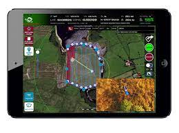
But exactly how are these drones able to perform so well? For DroneSar, capturing the necessary information is one way the drones are able to perform at such a high level. Via the DroneSAR app, drone pilots choose automatic flight functions and communicate and share live data in real time. When information is suspected to be of use, it is also relayed for assessment. Analysis is closely linked to assessment and visualising the data is crucial in mission-critical operations in order to extract the necessary information.
However, drones do have their limitations. One of these limitations is the battery life: drones are dependent on batteries and even the longest-flying drones cannot fly for more than about half an hour. Another limitation is the weather: drones are affected by poor weather conditions, in particular rain and strong winds, which can be a serious impediment to a search.
It is clear that drones on their own are not enough and they will not replace search and rescue. Drones require an experienced and expert team behind them in order to perform to well and produce the best results. However, drones do have the potential to drastically improve search and rescue results thanks to their ability to navigate rough terrain, to communicate in real time the information they have found, and finally their speed, which can make the difference between life and death.
References:
Image of Co. Donegal: https://www.discoverireland.ie/donegal
Image of DroneSAR app: https://www.dronesarpilot.com/
Information on DroneSAR: https://www.dronesarpilot.com/

Recent Comments